Contents
Index
Field Station Setup Properties
A Field Station Setup is used when you have setup the theodolite on a field station and have taken some observations. There are certain data items for the station setup which are recorded and are used during the reduction to compute the XYZ values for the observed points.
Setup Station Name
Enter the name of the setup station.
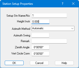
Height of Instrument
The height of instrument is used to compute the XYZ values for the points observed from this station. If left blank, the XY values can be computed for the points, but no height can be calculated.
Azimuth Method
You can set the method used to compute the Azimuth Swing as follows.
- 0 - Automatic - This automatically computes trhe Azimuth Swing as follows:
- If the Station Setup 'Azimuth Swing' field is not blank, it will be used.
- If the first observation has an 'Obs Stn' and 'Horiz Bearing', it can compute the Azimuth_Swing = Brg_to_Obs_Stn - Horiz_Brg.
If this value is within 20" of 0 degrees, it will be corrected to 0 degees.
- If the first observation has a 'Horoiz Bearing' and no Slope/Horiz Dist, the Azimuth Swing is the Horiz_Bearing value only
(The swing is actually the negative value of Horiz_Bearing).
- 1 - Use Stn Azimuth Swing Value - Use the value on the station setup
- 2 - Use Next Obs Stn to compute - If the first observation has an 'Obs Stn' and 'Horiz Bearing',
it can compute the Azimuth_Swing = Brg_to_Obs_Stn - Horiz_Brg.
If this value is within 20" of 0 degrees, it will be corrected to 0 degees.
- 3 - Use Next Obs Bearing Value - If the first observation has a 'Horoiz Bearing' and no Slope/Horiz Dist, the Azimuth Swing is the Horiz_Bearing value only
(The swing is actually the negative value of Horiz_Bearing).
- 4 - Use Zero (0) - set the azimuth value to 0 degrees
- Note: The Sessions setting 'Zero Azimuths' overrides all the above and always sets the Azimuth to 0 degrees
The Automatic method is the default for all station setups and is compatible with all existing field obs data in .acs files.
If with wish to always use say method '2 - Use Next Obs Stn to compute', you can set the default value in the
GeoSurvey Config file for the <fieldStnAzimuthMethod> option.
Set it to a number 0,1,2,3 or 4 to set the dafault Azimuth Method value for new station Setups.
Thus when you import a field data file, this value will be applied to all station setups
Azimuth Swing
The Azimuth Swing is the correction angle which is to be added to each observation bearing to correct it.
See above for the best way to compute this value.
Remark
Optionally enter a remark for this station setup.
Zenith Angle
This sets the orientation of the vertical angle system. Normally 0 degrees is straight up (default). If your theodolite is different, enter the angle for straight up. If left blank, it will be assumed to be 0 degrees.
Vertical Circle Correction
This sets the vertical circle correction. Depending on the instrument, then can be a few minutes. This correction will be added to every vertical angle used when reducing points.
Field Obs Reduction Rules
Click here for more information.